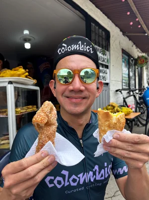
The complete field guide to road cycling in the Colombian Andes.
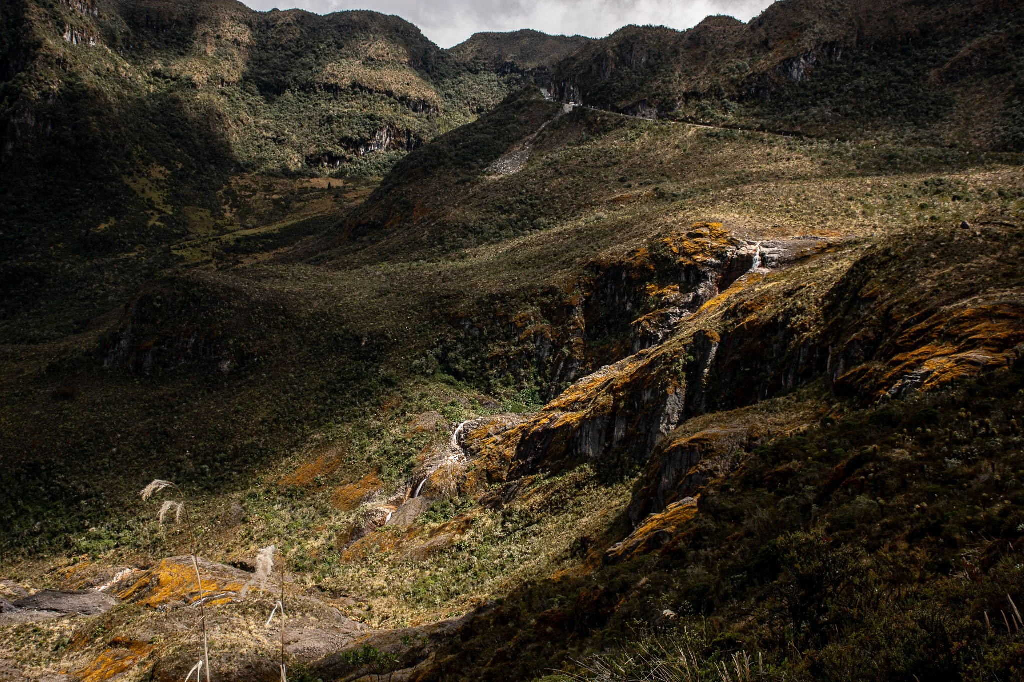
Above 4,000 m in Colombia's high páramo of PNN Los Nevados. Photo by Fotografo Alto de Letras.
Equatorial geography creates an anomaly in the Andes: high-altitude alpine terrain where logic says it shouldn't exist, a reality few cyclists grasp until riding it firsthand.
Every mountain range obeys the same laws of elevation, until it meets equatorial geography. Across European passes, alpine boundaries are drawn sharply: forests give way around 2,000 to 2,400 m (6,600 to 7,900 ft), permanent snow settles under 3,000 m (9,800 ft), and anything higher means frozen rock, ice, and seasonal closures. Colombia sits directly under the equatorial sun, where constant year-round solar intensity overrides the winter drop that pushes those boundaries lower everywhere else. Vegetation here climbs to 3,200 to 3,500 m (10,500 to 11,500 ft), and glaciers hold near 4,500 to 5,000 m (14,800 to 16,400 ft), significantly higher than the Alps, in places close to double.
Inside those boundaries sits the páramo, a populated, cultivated ecosystem thriving at an altitude where the usual rule is frozen stone and nothing else. Colombia paved a corridor straight through it for freight, and the effect on a bicycle is the same regardless of intent: terrain that should be uncrossable on two wheels, crossed anyway.
I'm Pan. Maya and I have lived and cycled across five continents together, and we chose Colombia as home. I've spent the years since riding and testing the roads in this guide.
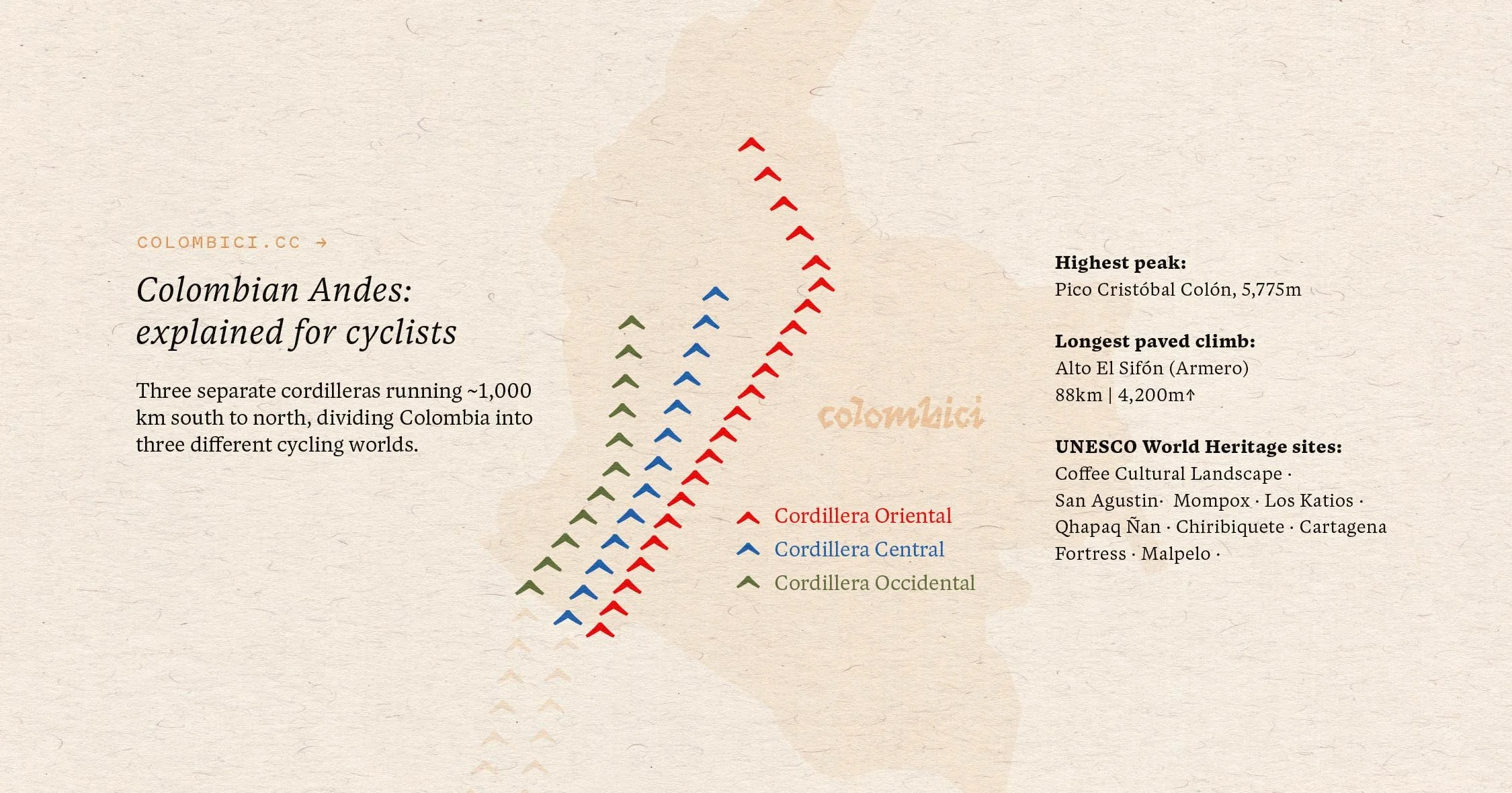
Three cordilleras, one country, cycling worlds apart.
The Colombian Andes and altitude
A mountain on the equator has no real winter. The sun strikes at nearly the same angle every day of the year. Without a cold season, the seasonal shutdown that closes high terrain everywhere else never happens here.
Instead, the day itself does that work. Mornings run hot, nights run near freezing, and that daily swing stands in for the annual one that governs mountains at higher latitudes. Climatologists call this a diurnal climate, distinct from the seasonal climate of the Alps or the Rockies. It's why a summit here can carry permanent snow while farms and small towns sit only a few thousand metres below it, an elevation band that would be barren rock anywhere with a true winter.
Latitude alone doesn't cause this. Most of the equator is lowland, jungle, or ocean, and none of it produces what the Colombian Andes produce. The effect needs two things at once: equatorial position, and enough elevation for that position to matter. Very few mountain ranges on Earth have both. East Africa has it in isolated patches, a scatter of volcanic peaks covering a few thousand square kilometres. The Colombian Andes have it as one continuous corridor, three parallel cordilleras running the length of the country, forming the largest stretch of this terrain anywhere on the planet.
The roads through it were never built for cycling. They exist to move freight between the coast, the interior, and the coffee highlands. A road bike can now cross a genuine equatorial high-altitude ecosystem, from snowline to farmland to tropical valley floor, without leaving pavement. Almost nowhere else offers that.
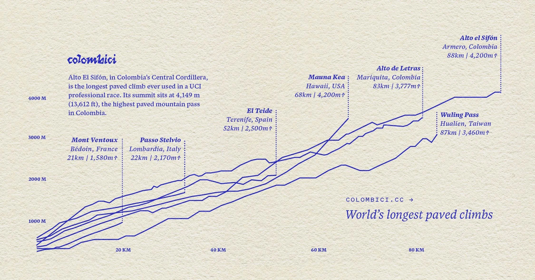
Alto El Sifón is the longest paved climb ever used in a UCI professional race.
Altitude, oxygen, and heat
Above roughly 3,000 m (9,800 ft), oxygen availability drops in a way every rider feels, regardless of fitness. Blood oxygen saturation falls from around 97 to 98 percent at sea level to closer to 80 percent near 3,000 m. Aerobic power drops by roughly 6 to 8 percent for every 1,000 m (3,300 ft) gained above about 1,500 m (4,900 ft).
A rider at 4,100 m (13,500 ft) can expect to lose upward of a fifth of the power they'd produce at sea level for the same effort.
We build every itinerary around this rather than against it: an easing-in day on the Bogotá savanna before any serious altitude, the hardest climb placed mid-week, a support vehicle present on every ascent above 3,000 m. It isn't caution for its own sake. It's the only sequencing that works, and we've seen what happens to the trips built the other way round.
The heat at the bottom is the other half of the problem, and it's logistical rather than physiological. Mariquita and Honda sit around 450 to 470 m (1,480 to 1,540 ft) and regularly hit 30 to 35°C (86 to 95°F) by mid-morning. Standard local practice is a 5 to 6 a.m. start, off the saddle and into the climb before the valley turns hostile. A rider still suffering in that heat by 9 a.m. isn't experiencing the country's extremes. They're experiencing a start time we got wrong.
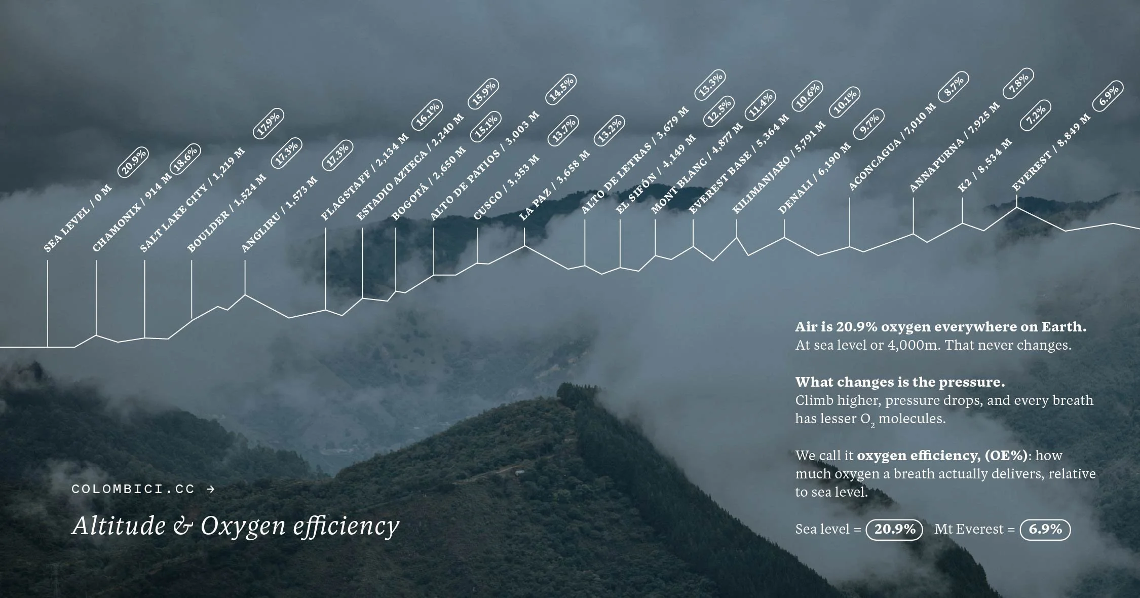
Air is 20.9% oxygen everywhere on Earth, but altitude changes how much of it each breath delivers. Photo by Mateo Rueda.
The páramo ecosystem
Colombia holds close to half the world's páramo, roughly 2.9 million hectares (7.2 million acres) across 36 complexes, a figure from Colombia's own Instituto Humboldt, though some international sources put it closer to 43 percent depending on how the ecosystem's edges are defined. Roughly 76,000 people live and farm inside it, at an elevation most countries leave uninhabited.
Deep, spongy volcanic soil holds rainfall and fog moisture and releases it slowly, which is why rivers fed by páramo run steady instead of flooding and drying by turns. Chingaza, the complex closest to Bogotá, supplies about 70 percent of the capital's water. Nationally, páramo water reaches an estimated 17 million people.
Frailejones, the tall, fuzzy-leaved plants lining these climbs, catch fog moisture on their leaves and channel it to the ground. The figure most often repeated for their growth, including in our own earlier writing, is 1 cm (0.4 in) a year.
A 2018 study that radiocarbon-dated real specimens found actual growth rates of 3.8 to 6.9 cm (1.5 to 2.7 in) annually, five to seven times faster than the number everyone repeats.
We'd used the old number ourselves for years before checking it. The plants lose nothing by the correction. Nobody had measured properly until recently.
Frailejones on the road to El Sifón. Photo by Fotografo Alto de Letras.
Cycling regions of Colombia
The Bogotá savanna, at 2,625 m (8,612 ft), is the highest starting point of any major cycling region on earth. Alto de Patios, out of the city to around 3,000 m (9,800 ft), ranks among the most-attempted climbs on Strava worldwide, a figure that says more about how many riders live at its base than about the climb's severity. The savanna's better riding sits north and west, a rolling plateau of reservoirs and pine broken by climbs like La Cuchilla de Guasca, which tops near 3,360 m (11,020 ft), higher than any summit in Mallorca or Girona, and functions here as an ordinary Saturday. Smaller, sharper climbs sit scattered across the savanna floor itself: Alto de Mondoñedo, near Mosquera, gains 177 m (580 ft) over 3.5 km (2.2 mi) at an average 5.2 percent per myCols, a short Category 3 effort locals use as a weekday sharpener, one of a cluster of similar climbs, including one literally named Alto de los Escarabajos, the climb of the beetles.
The Magdalena valley is where the road drops from altitude and the country changes underneath the wheels within two hours, cold and thin at the top, warm and dense at the bottom. These roads carry the mulas, freight trucks, moving between the coast, the interior, and the coffee belt, paved for exactly that purpose long before cyclists arrived. This is also the approach to El Sifón, the highest paved pass in the country at 4,149 m (13,612 ft).
Eje Cafetero, spanning Quindío, Risaralda, and Caldas, sits at roughly 1,200 to 2,000 m (3,900 to 6,600 ft), close to exactly the elevation band where coffee grows best. The region's coffee landscape was inscribed as a UNESCO World Heritage site in 2011, covering six farming landscapes and eighteen towns. The quiet riding runs the backroads between them, well clear of the standard circuit.
Boyacá is high, agricultural, and more saturated with cycling culture than almost anywhere else in the country, and has produced a disproportionate share of Colombia's professional riders. The reason is visible from the roadside: working roads at serious altitude, ridden for generations by people who were never doing it for sport.
The Caribbean coast and the Sierra Nevada de Santa Marta. The range rises from the coast to snow-capped peaks above 5,700 m (18,700 ft) in just 42 km (26 mi), the highest coastal mountain range in the tropics and among the highest coastal ranges anywhere, though not the unqualified world record, Canada's Saint Elias Mountains stand roughly 250 m taller. Coastal riding runs northeast toward Palomino, a quiet surf town growing quickly, and inland climbs push up toward Minca for views back over the Caribbean.
Antioquia, centred on the highlands around Medellín, is where Colombian climbing culture is generally said to have taken shape. El Retiro, the town at the centre of it, sits above the city amid short, punchy, near-constant rolling terrain. Paisa country, a region defined as much by craft, ceramics, woodwork, hand-built steel, as by cycling. Scarab Cycles, based here, still builds steel frames by hand. Loops out of El Retiro run through La Ceja, Rionegro, and El Carmen de Viboral to the north, and out toward the historic town of Abejorral to the south, one of the more demanding days in the region at around 110 km (68 mi) with 3,000 m (9,800 ft) of climbing and no flat sections at all.
Valle del Cauca, around Cali, runs broad sugarcane valley flats framed by two cordilleras into demanding climbs on the edges. Cali hosts El Giro de Rigo, the gran fondo built around Rigoberto Urán, run every November with two route options named for the region's own identity rather than a generic distance label, Reto Salsa and Reto Caña, cane and salsa standing in for the two things Cali is known for beyond cycling.
Nariño, hard against the Ecuadorian border, sits among five named volcanoes, Galeras, Doña Juana, Cumbal, Azufral, and Chiles, and a day's ride here regularly clears 3,000 m (9,800 ft) of climbing before it's over. It remains one of the least-ridden corners of the Colombian Andes by visiting cyclists, despite terrain that matches anything further north.
Santander. Cañón del Chicamocha, cut by the Chicamocha River, runs 227 km (141 mi) long and up to 2,000 m (6,600 ft) deep, widely cited as the second-largest canyon in the world, though the exact metric behind that ranking, depth, length, or volume, isn't always made explicit by the sources repeating it. Nearby, the climb locals call the longest ascent in Colombia, Alto del Picacho, runs roughly 48 to 50 km (30 to 31 mi) with about 2,400 m (7,900 ft) of gain to a summit near 3,300 m (10,800 ft), starting from Girón or Piedecuesta outside Bucaramanga. It now has its own annual event, the Picacho Challenge, which drew around 1,200 riders in its third edition in September 2026, per the race organizers. Worth noting plainly: Picacho's claim is a different superlative from El Sifón's "longest paved climb ever used in a UCI race," one measures a training climb, the other a raced stage, and both can be true at once without contradicting each other.
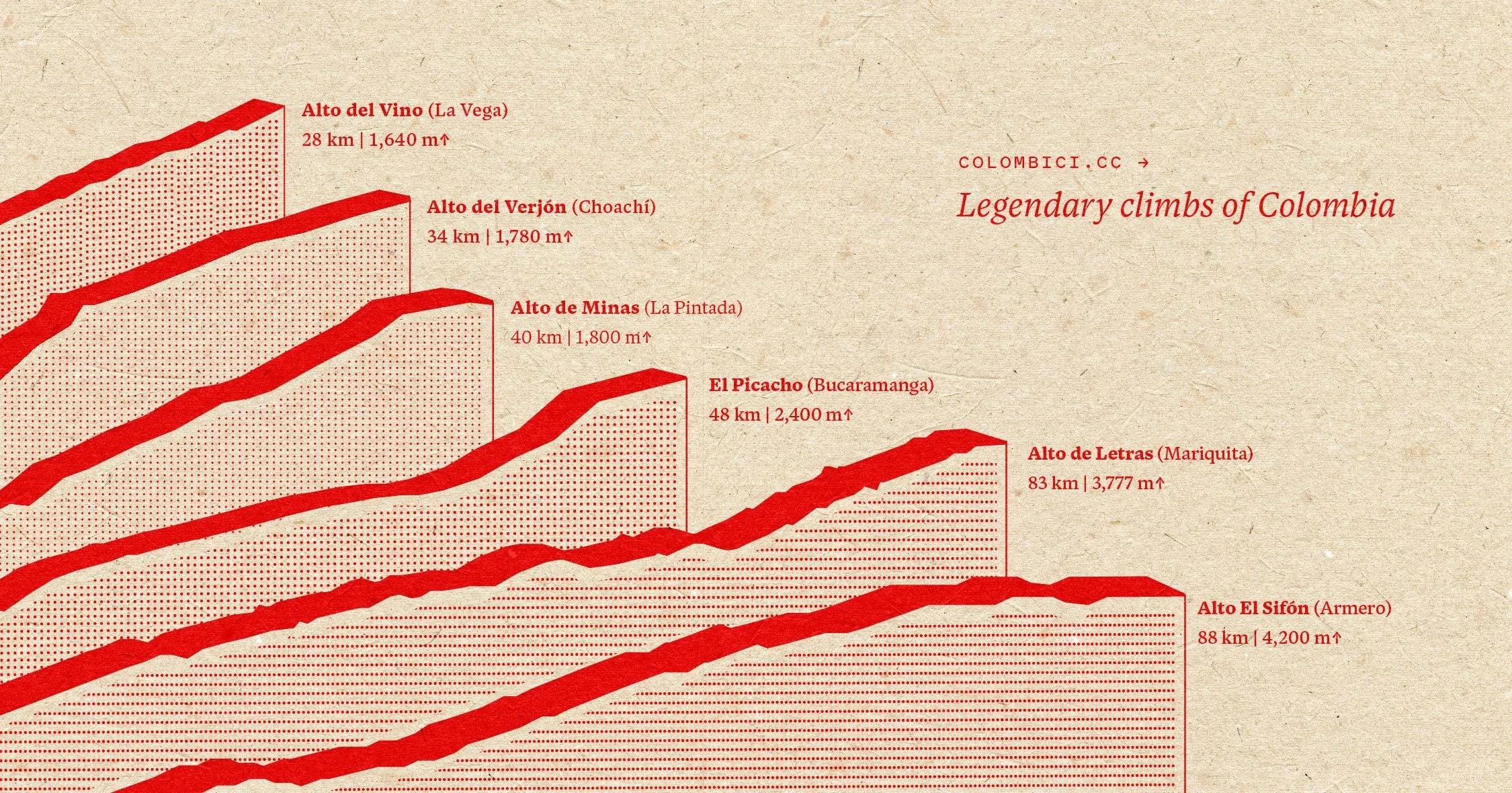
Colombia's iconic mountain passes rank among the most demanding paved climbs anywhere on Earth.
How Colombian climbs compare
Continuous paved ascent, measured against the rest of the world
Mauna Kea's upper section turns to gravel. El Sifón stays paved the entire way.
| Climb | Country | Length | Elevation gain | Summit |
|---|---|---|---|---|
| Mauna Kea | Hawaii, USA | ~69 km (43 mi) | ~4,200 m (13,800 ft) | 4,205 m (13,796 ft) |
| Alto del Sifón | Colombia | 88 km (55 mi) | 4,200 m (13,780 ft) | 4,149 m (13,612 ft) |
| Alto de Letras | Colombia | 83 km (52 mi) | 3,777 m (12,395 ft) | ~3,680 m (12,070 ft) |
| Alto del Picacho | Colombia | ~48 km (30 mi) | ~2,400 m (7,900 ft) | ~3,300 m (10,800 ft) |
| Stelvio | Italy | ~24 km (15 mi) | ~1,800 m (5,900 ft) | 2,758 m (9,048 ft) |
| Mont Ventoux | France | ~21 km (13 mi) | ~1,600 m (5,250 ft) | 1,909 m (6,263 ft) |
| Alpe d'Huez | France | ~13.8 km (8.6 mi) | ~1,100 m (3,600 ft) | 1,850 m (6,070 ft) |
The culture behind the climbing
Colombian cycling has a specific vocabulary worth knowing before arriving. Strong climbers are escarabajos, beetles, a name a radio commentator gave five-time national champion Ramón Hoyos in the 1950s, watching him climb like a beetle on a bicycle. It's been applied to every generation of Colombian climber since.
The first Vuelta a Colombia ran in 1951, on unpaved roads, won by Efraín Forero, who also helped design the route and crossed the old Letras pass, then unpaved, on the way to victory. Thirty-three years later, in 1984, Luis "Lucho" Herrera became the first Colombian to win a Tour de France stage, on Alpe d'Huez.
Below professional level, the sport runs closer to infrastructure than hobby. Bogotá's Ciclovía, founded in 1974, closes 141.46 km (88 mi) of the city's main roads to cars every Sunday and public holiday, drawing more than 1.5 million people a week, per Bogotá's IDRD, the oldest programme of its kind anywhere on earth.
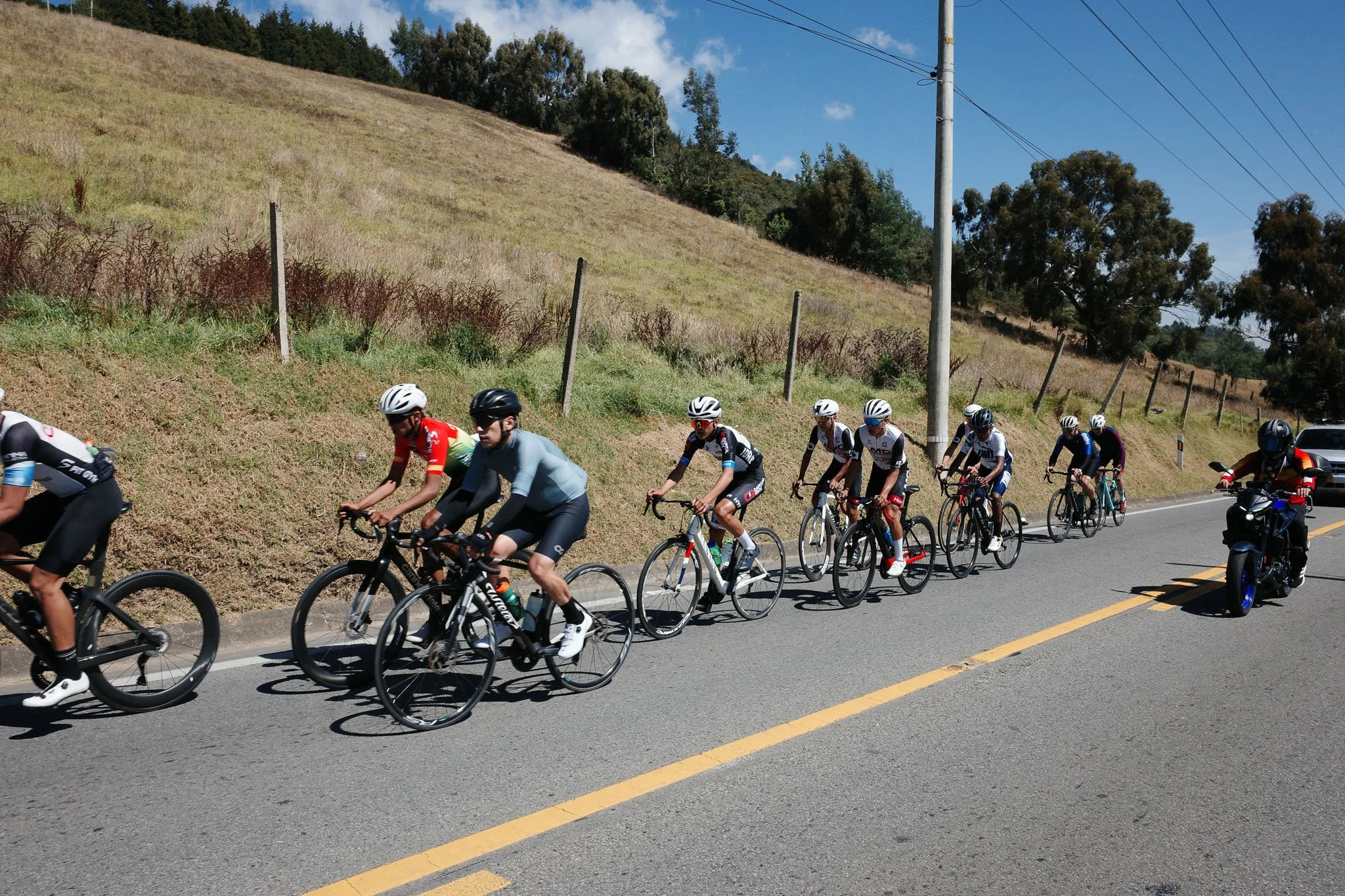
Cycling runs deeper here than almost anywhere in the US or Europe, closer to daily infrastructure than to sport.
Nowhere else
There are other tropical alpine landscapes on Earth. Ethiopia has the Bale and Simien highlands. Kenya and Tanzania have Mount Kenya and Kilimanjaro. New Guinea has a high spine of its own. Each is remarkable, and each is a scatter of isolated peaks: sky islands, separated by lowland, holding a few thousand square kilometres of high terrain between them.
None of them is a corridor. None of them lets a road run continuously from tropical valley floor to páramo above 4,000 m and out the other side into coffee country. Colombia is the only place where this landscape is large enough, connected enough, and paved enough to be crossed on a bicycle.
That is the whole argument. Not that Colombia has good climbs, though it does, or that it has cycling culture, though it has more than most. It's that the geography itself occurs at scale in exactly one country, and you can ride through the middle of it.
Maya and I chose Colombia as home after living and cycling across five continents together. Somewhere between the Caribbean heat and the high Andean páramo we realised the country had a story worth sharing, and every route we run since has been built to tell it: family-run lodges, working farms, small towns, roads ridden and tested before anyone else is invited onto them. Cycling with intention, in a place that shouldn't exist.
Into Coffee Heartlands: six rides, seven nights, Bogotá to Filandia
—
Sources include Instituto Humboldt, IDEAM, DANE, Bogotá's IDRD, UNESCO, myCols, and Tobón et al. (2018), Plant Ecology. Figures for climb lengths and elevation gain vary between sources; where they conflict, the most commonly cited range is given. Written and maintained by Colombici, Bogotá.
All photography and graphics by Pan Yamboonruang except where credited.
Glossary
The words you'll hear on the road
Páramo
A high-altitude tropical ecosystem sitting between the treeline and the snowline, roughly 3,000 to 4,500 m (9,800 to 14,800 ft). Found almost exclusively in the northern Andes. Colombia holds close to half the world's total.
Pisos térmicos
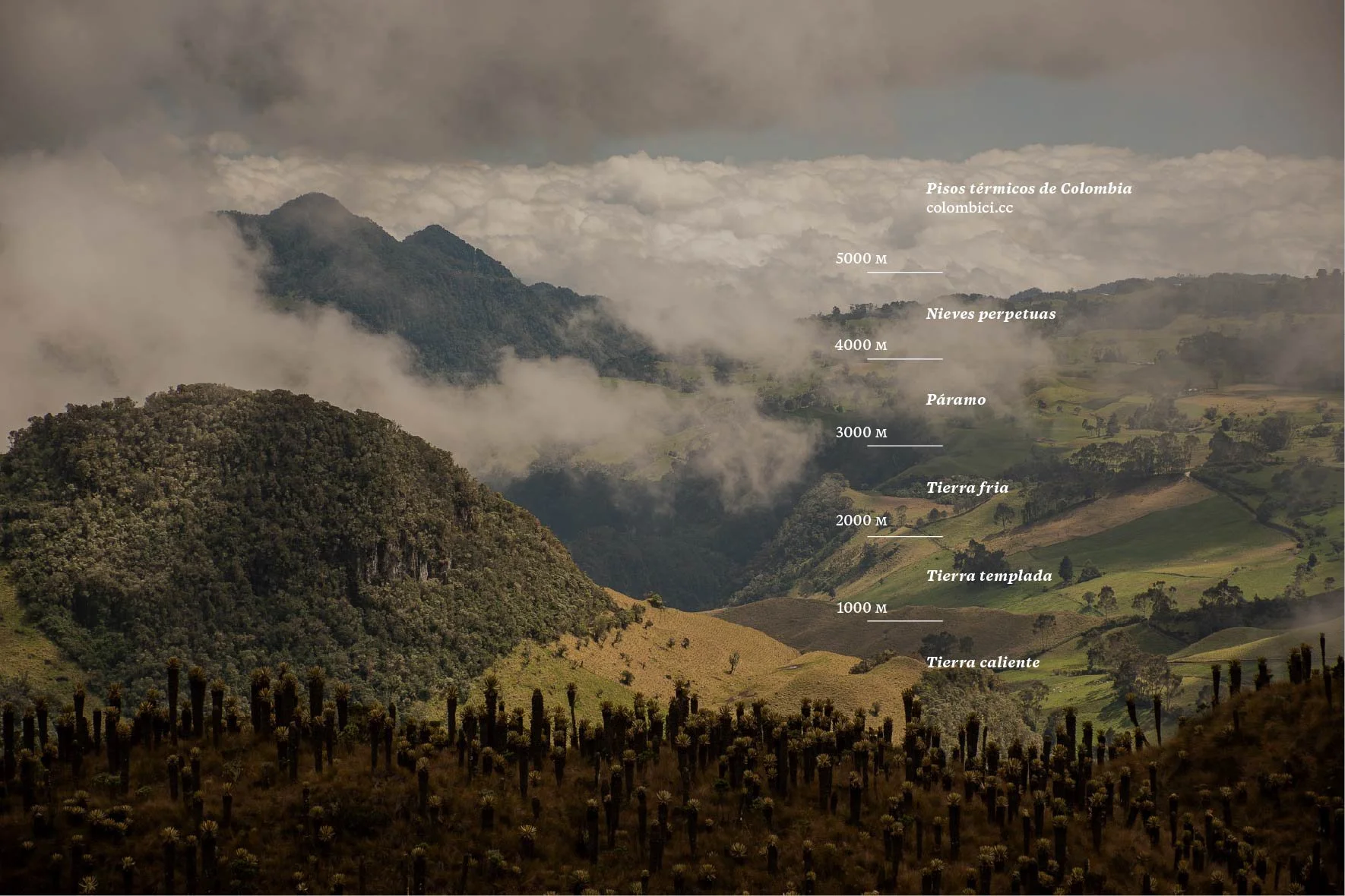
Colombia's thermal floors: climate bands stacked by elevation rather than season, each holding a permanent climate. Tierra caliente below 1,000 m, templada to 2,000 m, fría to 3,000 m, páramo above that.
Frailejón
Espeletia, the tall rosette plant that defines the páramo landscape. Its hairy leaves capture moisture directly from fog and channel it into the soil.
Escarabajo
Beetle. The nickname for Colombia's climbing specialists, coined in the 1950s and used for every generation since.
Mula
Colombian Spanish for an articulated freight truck. The vehicles the country's mountain roads were actually built for.
Diurnal climate
A climate where the daily temperature swing exceeds the annual one. Standard on equatorial high mountains, where there's no real winter but every night runs cold.
Ciclovía
Bogotá's Sunday street closure programme, running since 1974. Now 141.46 km (88 mi) of car-free road every Sunday and public holiday.
Frequently asked questions
Planning a trip to the Colombian Andes
Is it safe to cycle in Colombia?
Yes, with sensible route choice. Colombian driver culture treats cyclists as normal traffic rather than an obstruction, since the sport is mainstream here, and mountain roads are shared as routine. The country is a long way from its 1990s reputation. In practice the real risk on a Colombian cycling week is weather and unfamiliarity, descending through mountain fog on roads nobody in the group has ridden before.
When is the best time to ride in Colombia?
Any month. Climate here runs on altitude rather than season, so high passes never close and Bogotá holds 14 to 20°C (57 to 68°F) year-round. What changes is rainfall: wetter periods run roughly April to May and October to November, drier ones December to March and July to August. Rain at altitude usually arrives as an afternoon burst rather than a settled week.
How long is the Alto del Sifón climb?
88 km (55 mi) from the Magdalena valley floor to a summit at 4,149 m (13,612 ft), 4,200 m (13,780 ft) of total climbing across the route. It's the highest paved pass in Colombia and widely cited as the longest paved climb ever used in a UCI-sanctioned race.
How hard is riding at altitude if you live at sea level?
Expect to lose roughly 6 to 8 percent of your aerobic power for every 1,000 m (3,300 ft) above about 1,500 m, so upward of a fifth at 4,100 m. Most riders feel it as reduced power at a familiar heart rate rather than as illness. The first two or three days are the hardest, which is why any well-built itinerary starts gently on the Bogotá savanna.
What's the difference between Alto de Letras and Alto del Sifón?
They're two separate high points on the same ridge of the Cordillera Central, often confused. Letras is the older, lower summit at roughly 3,680 m (12,070 ft), reached from Mariquita. El Sifón is higher at 4,149 m (13,612 ft), reached via Líbano and Murillo, and its final section was only paved in 2023.
What gearing should I bring?
Compact, and more range than you think. Climbs here last hours rather than minutes, so a gear range that feels generous at home turns out to be merely adequate.
Do I need to bring my own bike?
Most serious visiting riders do. Rental quality varies significantly by operator and city, so if you're renting, confirm exactly what's in the fleet rather than assuming.